23/7/2014 Redencao to Xinguara
D113, T6, Av19.64, Max38, 30,806/5182
Hot, slight sou wester
All asphalt
I was totally ready to move on, so was up at 0500, feeling pleasantly refreshed.
The gear was packed and just a coffee had.
The bike was rolled out the door at 0630, an early start, the sun still was not up.
I went across the road to where a guy in a bread shop had given me his wifi password last night and checked emails etc.
It was great riding again with mainly just local traffic, trucks included.
Once out on the open road, the kilometres were just slipping by. At 1000, I pulled in at Bambú and ate a few empanadas and drank chocolate milk and of course a can of Coke. I might have a little problem with this stuff.
Heaps of people were asking me questions. I returned answers and also more questions. Anyway, 45km down a dirt road to Floresta at the shop was a Abacaxi or Pineapple farm.
I could not believe it when the guy said it was 13,000 ha, they export to the whole world.
This place is known as the pineapple capital of the world, no wonder.
As he was leaving, I yelled out across the carpark, “hectares or acres”? Just to be sure. He replied hectares.
The terrain is now getting very lush, it has all turned green and is largely, where cleared , occupied by the endemic palm locally known as Babacu.
Riding was still a pleasure although the road was narrow and a few times trucks would toot from behind and I would just track off the new asphalt onto the grass and return when all was clear. These truck drivers in BR so far have been so easy to co exist with on the roads.
By 1200, the heat was starting to kick in, pulling over my flapped peak hat was put on. The seat was given a little tweak with the wrench and off proceedings went. Soon Vila Maria was upon me. Still with plenty of water I rode straight through.
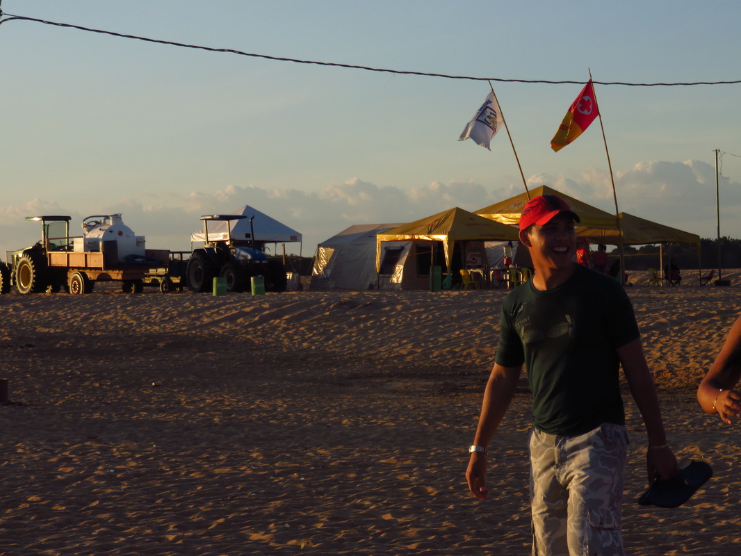
By 1230 I was in Xinguara, it was probably one of the earliest arrivals with 100 plus km logged.
The decision was made to stay here.
I booked a highway budget hotel. The bike was left outside against the wall by the owners desk. Its safety did not overly concern me.
The bar bag was taken off, I payed the guy and lay down on a bed in reception and began watching a movie.
Well in no time, I was sound asleep, totally exhausted.
I awoke with a start, some half hour later to get the bike. Well it was not there. Being still half-asleep and bare footed, I ran out onto the dirt parking area to see if I could see someone with it.
I was totally spaced out.
My world had suddenly changed. Going back to see the young guy who ran the place. I was relieved beyond words, there was the bike in a side alley inside the hotel. He had kindly moved it while I slept.
I had a quick insight into the worst possible thoughts of a touring cyclist, I know of a couple who have had their bikes stolen.
It is not a nice thing to have to contemplate.
Lately, I have been getting a bit too casual and trusting. This was a little wake up call.
Relief overcame me like a heavy shower of rain. Though, I was still a bit shocked.
Soon over it, a wander was taken to a supermarket for fresh fruit.
A great meal and a couple of beers were enjoyed on a busy corner on Ruta 150, as it is now known here in Pará. The people were cooking bacon wrapped beef kebabs over charcoal and serving them with rice, mandioca and at dozens of plastic tables
The sweet smelling smoke was wafting all the way up the main street into town .It is such a pleasure to see people just getting on with stuff.
Back in Aussie, the do gooders would be complaining like there was no tomorrow. I can just picture the fire brigade in all their glory coming to put out the BBQ.
Where did we go wrong. There is no comparison between a charcoal cooked kebab and that on gas.
It is so ridiculous, this is not allowed at home, as 1000 cars drive past during the evening, belching out their unseen and accepted pollution. Maybe people think cooking without sweet smoke flavouring the food is more civilised in public places!
BR truly is an industrious nation. There were all these trucks just carrying 20ft German line containers on 5 axles. On asking, a guy told me it was copper going to Belem to be shipped.
The bike was not unpacked, as all my eating items are in the front pannier, so just a mint tea was enjoyed, heating the water with the MSR on the concrete floor in the basic but adequate room.
Once 7 degrees latitude was reached today, as said above, the scenery took on a real lush appearance. There were hills on the horizon and the country now more undulating and for a change, no more flat paddocks full of Soya.
Some guys stopped me to take photos on the highway and give me bottled water. I asked about Jacaré in the water holes, they said north of Marabá is where they become more frequent.
I will still be wary about camping near dirty water.
24/7/2014 Xinguara to 10km south of Eldorado dos Carajás
D133, T10, Av17.79, max41, 30,940/5405
Hot clear, 35°
A few mosquitoes in my room had made for interrupted sleep, the small fan had to be adjusted to force air onto my face just to stop them bombing me.
On the road about 0730, a ride was taken into town to buy bread.
I really was lucky to still be sitting on the seat of a bike, it is scarey just thinking about losing everything.
Bread was bought at the supermarket and once back on the main road the shoulder was non existent.
Luckily, traffic was not so heavy.
Each creek crossing a quick look over the rails, that’s when they were still intact, was taken to look for Jacaré.
Many guardrails had were seen in the creeks or hanging from the bridges.
None were seen. Soon the road deteriorated into patches of gravel. These sections sometimes a few km in length other times just a couple of hundred metres were littered with huge pot holes. Trucks were all over the road trying to avoid these axle breaking depressions. I was again keeping up with and passing some articulated trucks.
Just tracking on a fine line, it was easy for me to find passage through the obstacle courses. The dust was unreal. If a vehicle was travelling fast the dirt particles within it could be felt on my face.
During the clearing process here, the settlers left mainly just palms in the paddocks. They now stand as solitary reminders of what must have been growing here.
Some were 20m tall, so the native vegetation must have been of some stature.
Some of the bigger rivers had thatched shaded areas and a beach on the shores.
Negotiating one of the gravel sections, a guy in a bus stopped near me. He had no passengers, but tubs of polystyrene plates of prepared meals of rice, chicken, mandioca and beef. He opened the side door of the small vehicle and passed me a plate full of food.
It was so timely. What a fantastic gesture I thought. My next issue was to find a piece of shade to sit down and enjoy it.
A small tree up ahead on my right cast a small shadow onto the side of the rod. Here this food was eaten with haste, I was famished. Even the included dust was palatable.
Energy levels were back to normal again.
After some 70 km, I pulled into a large restaurant come gas station. They had a huge buffet on offer. This didn’t appeal to me. Instead, an icy1 litre bottle of coke was bought. I personally chose it from the display fridge it had been lying down and was super cold. On pouring the first glass, it was an icy slurry.
Now to say this was just astoundingly divine and refreshing, is still understating the contents of each glass. The sweet icy liquid could be felt exploring every inch of my exsiccated throat as it descended to my stomach.
It was akin to urinating on dry dusty soil and watching the liquid track through the dryness and being absorbed along the way. Like water entering a desert.
The first bottle disappeared within 5 minutes. A second was ordered. It too, divinely moistened my throat and wet my wellbeing during its journey.
I have learnt now. Not only to drink and eat to how I feel at the present moment, but to consume for the next 20 or 30 km.
It often means leaving these places totally bloated or feeling like too much has been drunk.
Without fail, this feeling dissipates within 10km, leaving me pleased that I over indulged.
The secret to riding in this heat and dust, is to never get into state of hunger or dehydration.
A wall will come up so incredibly quick.
I have been riding along and within 10 minutes, my disposition can change so rapidly. From feeling fine to feeling weak and unable to go on.
In the heat during the early afternoon, no matter how hydrated I am, my throat gets so incredibly dry, It is the heat burning it. At a gas station a temp gauge read 36°.
This is where these Halls Eucalyptus sweets come in so handy. They keep the mouth moist. Two packs are often eaten in a day.
All these dietary habits would be a health disaster in a normal existence without exercising all day.
Today 3 litres of coke were drank, back home I do not even drink the stuff.
Though, now scarily, sometimes I feel the urge for a bottle. That it is easily available in glass bottles makes it even more desirable.
Incidentily, many years ago on ringing the info line to coke in Australia, they informed me that for every 100ml of the drink there is a teaspoon of sugar.
That is 30 teaspoons of sugar, scary, but I believe it is burnt. Personally, I have never felt healthier.
This is an explanation found on livestrong.com
Whether you're munching on a candy bar or scarfing down your favourite pasta, the carbohydrates you eat are eventually broken down to glucose in your digestive tract. From there, they are either used for quick energy or stored for later use. Learning more about how your body stores and burns the food you eat will help you eat and exercise smarter for better health and performance.
From Food to Fuel
The foods you eat can be subcategorized into fats, carbohydrates and proteins, and while all three can be used to fuel your body, carbohydrates are the fuel most readily used for physical activity.
Carbohydrates come from fruits, vegetables and grains, and are broken down into simpler sugars, fructose, galactose and glucose in your digestive tract. They are then absorbed in your small intestine and travel to your liver, where fructose and galactose are converted to glucose. A small amount of glucose is stored in your liver as glycogen, and the rest is transported via your bloodstream to tissues throughout your body to be used for energy or stored for later use.
Fuel Storage
Once it enters your bloodstream, the upswing of glucose triggers your pancreas to release insulin, a hormone that works like a key that opens the doors of your cells to let glucose in. If there is space for more glucose in your muscle cells, it's stored there in the form of glycogen, to be drawn on for future energy demands. But if your muscle stores are full, the excess glucose is converted to fat and stored as adipose tissue, or body fat.
Burn Baby Burn
The duration, frequency, type and intensity of your exercise will determine which fuel stores you draw on to meet your energy demands.
According to a review by Coyle, published in the "American Journal of Clinical Nutrition," low- to moderate-intensity activity draws on both fats and carbohydrates for fuel. As intensity increases, glycogen contributes more because fat cannot be oxidized quickly enough to meet energy demands. During moderate-intensity exercise, glycogen stores can contribute to energy production for two to three hours. Active people will deplete their muscle glycogen stores within 30 to 60 minutes of high-intensity intermittent exercise.
Energy levels can be maintained during endurance activities by ingesting glucose while exercising.
Balancing Act
After exercise, the carbohydrates you eat will serve to replenish your muscle glycogen stores within 24 hours. If you continually eat more sugar than you need, and don't exercise to burn off excess fuel, your cells will eventually become insulin resistant, predisposing you to diabetes. You will also gain weight, as excess sugar is converted to body fat. Regular endurance training improves your ability to use fats for energy and spare glycogen. Striking a balance between energy consumption and energy expenditure is the secret to optimal performance and weight management.
I like to think I have come somewhere close to finding this balance. Moving 50-60kg of gear 100 plus kilometres in a day must burn most things consumed.
Though reading other literature, soda drinks are not at all good when taken in quantity, even when exercising. It is other chemicals in the drink that are the problem, namely sodium and fructose.
Possibly, when other drink options are available, these will be consumed.
Though having said all this, during a normal day now, at least,4-5 litres of water are also consumed.
The environment, now was starting to take on a more imagined view of the Amazon area. That of smoke from burning forests and a pioneering spirit. Both were now present.
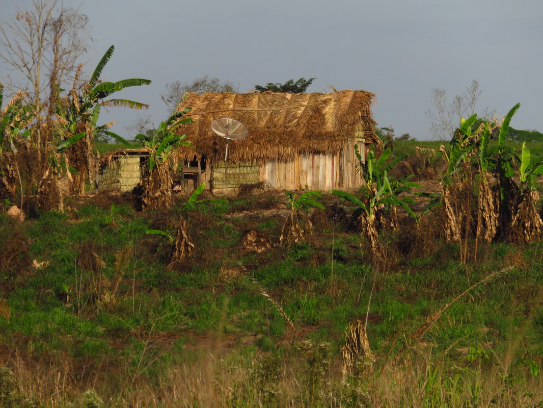
There was a smoky haze in the air and new settlements of thatched roofed houses were in abundance. Many properties were small holdings.
One property had a thatched roofed adobe house in the middle of a recently cleared piece of land, bananas were growing randomly.
The owners were sitting at the side of the distant dwelling. Most obvious was the presence of a pedestal mounted satellite dish alongside the house.
Adaptation from Care Dunns book:
The sacred order of survival:
1. Shelter
2. Water
3. Fire
4. Food
5. Satellite Dish!
Further on, the road passed through a section of natural vegetation. On approaching this, there were a couple of huge trees standing solitarily.
This was the first time I had seen a remnant of the forest. It must have been at least 30 metres tall with a canopy beginning near the top of the trunk. This giant must have been emergent in its prime.
Stopping at about 1730, I went into a property to ask if I could camp there. The owner and his wife were sitting under their veranda eating Brasil nuts. There were not happy for me to camp there. They gave me a handful of Brasil nuts and told me there was a town 12km up the road.
I thanked them and wandered back to my bike leaning on the gate post.
Riding on, a track off to the left side of the road was spotted. There were ponds in the distance.
I rode into here, when there was a gap in traffic.
The track through grass and low bushes, led me to three closely located ponds.
I knew there would be Jacaré in these, being man made I figured they would not be huge.
Whilst looking about for a camp site, the sound of a moto was heard.
Next thing this guy and his lady friend both about 30 pulled up and asked what I was doing.
In Spanish with some dodgey Portuguese thrown in, I tried to explain to them I was hoping to camp here.
He said there was a town 10km on.
I told him it was too dangerous now to ride in the late day.
We chatted more. I gave them some Brasil nuts. They seemed to warm to me.
They were probably people of humble existence.
They appeared to be of African extraction. Probably descendants from the slave trade.
Anyway, they showed me around the ponds, they had been dug out to provide fill for the highway.
He said there were only small Jacaré in the waters.
They describe their size in height above the ground. His hand was only raised a metre off the ground, he said they were not a problem.
A small one was seen near the bank eying us up.
When I say small, you could have fitted him in a small backpack.
They hand a sling shot with them for killing birds and he retrieved a fishing pole from the long grasses.
He had a bucket with him, his girlfriend and I fished for awhile with bread I had. He headed off for a shower.
They left me the bucket and fishing pole to use and told me a spot to hide it.
We chatted more and then they headed off just before dark.
They informed me this whole area is under water in the wet.
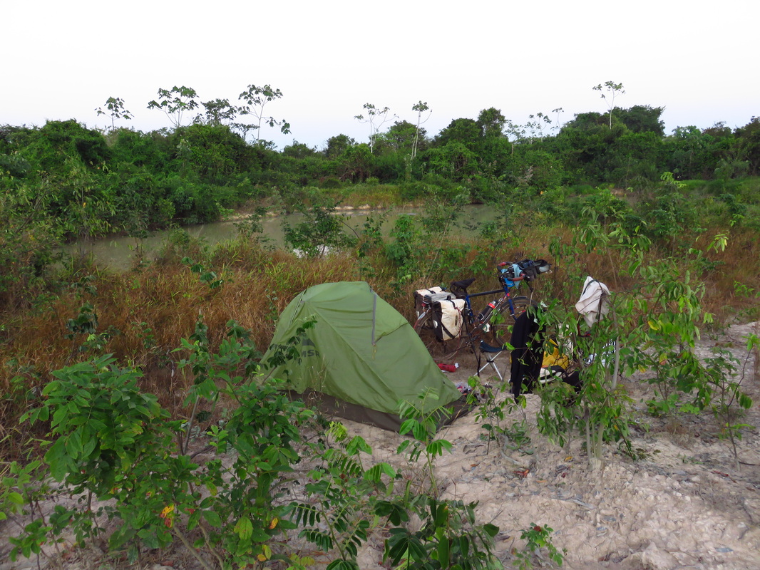
I set up camp by the smaller pond.
Before going to bed at about 2100. I took a wander to the other ponds. Sure enough, each one contained pairs of eyes that reflected strongly in my headlight.
The biggest pond had 4 sets and the middle one had three, my body of water had only two.
All the pairs of eyes were close together, indicating small specimens.
A second visit was made later, just for reassurance, still the same numbers.
I was happy to sleep here.
Though for the first time I took my knife into the tent. I don’t know why, but it made me feel better. I have no reason to harm anything.
It was a dark moonless evening, with a mass of tiny glimpses into the universe through the millions of stars above.
As usual, it was only minutes before one fell across the sky.
It was time for bed.
25/7/2014 El Dorado to Marabá
D111, T8, Av18.69, Max43, 31,050/ 5516
Fine. 36°
A good night’s sleep had been enjoyed, without any hindrance from animals or people.
The ant population was minimal, so the tent had been used. Not to mention that no suitable trees were present.
Up, and onto the road, unspotted by 0800, knowing El Dorado dos Carajás was just up the road.
Before leaving. I left a note and 10R in the bucket for the people. They had briefly let me see into their world, This was immensely enjoyed.
Yesterday, whilst stopped and talking to some ranchers, retrieving a calf from a ditch, a semi pulled up and the woman passenger threw a 10R bill to me. I did not understand the gesture, maybe it fell from my pocket on the rough road, anyway it had been nice to pass it on.
In El Dorado, a breakfast was enjoyed at a roadside stall., the woman was great. She had a great sense of humour and I could tell she loved cooking for travellers and locals alike. The beef was pressure cooked, it fell off the bone.
This town was a true pioneering location, there was dust everywhere, trucks being repaired, old cars, fires burning and a smoky odour in the air.
Getting closer to Marabá, there were brick works with furnaces all using wood to fuel them.
Bush clad the hills within view.
The road had improved greatly with a good shoulder. Most traffic was just local.
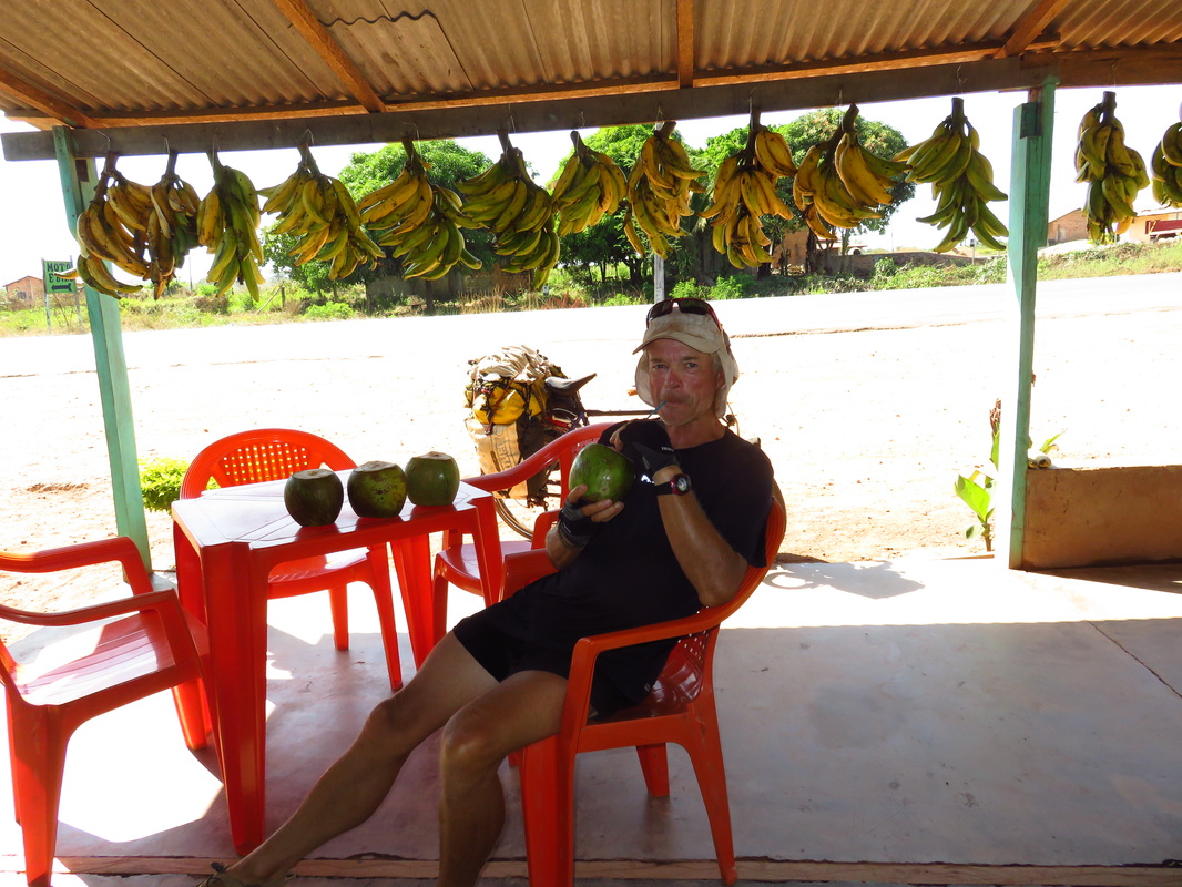
A stop was made at a small pueblo. Here 4 coconuts were drunk in rapid succession. It is great to be able to buy these. They keep me off the coke.
Riding on, the heat was really starting to kick in. Wanting to get to Marabá at a respectable hour, I kept riding.
Another small town was entered, here another 4 coconuts were drunk, the girl then cut them open for me to eat the newly forming flesh.
Water was drunk and a can of guarana, a popular soda drink here.
It was temping to sleep for awhile, next stop was at gas station 6km from the city. Here two divine pork chops were enjoyed with salad. The owner told me of a hotel of a cheap hotel in Marabá
Arriving in town, things were busy and dusty.
This was the biggest place visited since Asunción in PY. There was even high rise, 250,000 people reside here.
Getting here marks another milestone in my journey.
From here, I plan to head west on the Trans Amazon highway, Ruta 230, for 1100km of dust and steep little hills. Possibly some new tar?
This will take me to one of the primary reasons for embarking on this ride from Buenos Aires. The shores of the Amazon River.
I always dreamt of coming here as a young boy. Never in a million years would I have imagined sighting this river of rivers for the first time from the seat of a bicycle in my late 50’s!!
The next few weeks will see if this is to become a reality.
Thinking about what lay ahead, I treated myself to a luxury hotel, The Premier, at Nova Marabá for a few days. At $40 a night, it is the most expensive hotel booked for a long long time.
From Wikipedia
Marabá is a municipality in the state of Pará, Brazil. It's greatest geographical reference is the confluence of two large rivers near the historic city center, forming a "y" if seen from space. It basically consists of six urban centers, linked by five highways.
It is the fourth most populous municipality in the state of Pará, approximately 251.885[3] inhabitants according to the IBGE/2013, and the fourth largest GDP in the state of Pará, with USD $ 1.543.254,34 according to the IDESP/2010.[4] It's the main center of political, social and economic development of southern of Pará and one of the most dynamic municipalities in Brazil.
Marabá has a strategic position, is crossed by five highways. He also has a large logistics infrastructure, with port, airport and railway. The municipality has a growing industrial park, especially the steel industry, is important in agriculture, with a vast agricultural frontier, and also has a strong trade and services sector.
Marabá is characterized by its broad mix of peoples and cultures that do justice to the meaning of his nickname: "son of miscegenation".
History
The settlement of the river basin Itacaiunas played an important factor in shaping the city, because even though this region has been further explored by the Portuguese Empire in the sixteenth century, remained without a permanent occupation for almost 300 years. Only in 1894 is, in fact, the space was occupied by settlers.
Colonization
The firsts to participate in the colonization of the territory of Marabá, in 1894, were the political leaders who had escaped the political guerrillas in the northern Province of Goiás, specifically the city of Boa Vista.[5] One of these leaders was Carlos Leitao, who traveled with his group to the southeast of the province of Grão-Pará and established its first camp in downstream Itacaiunas River, in December 1984. Definitive village was established on the left bank of the Tocantins River, about 10 km downstream from the other camp, the place that Carlos Leitao called "Burgo do Itacayúna" (Burgo's Itacayúna). After a few months the extraction of rubber latex began in the "Burgo's Itacayúna" region.
In 1895 Carlos Gomes Leitão asks the President of the Province of Grão-Pará, José Paes de Carvalho, funding for the extraction and commercialization of rubber in addition to getting drugs to be used specifically to combat tropical diseases. To get funding, Carlos Leitão disseminating information on the extraction of rubber in small colony of Burgo's Itacayúna and its surroundings. Immediately there is the first population explosion of the locality where the rubber tappers, fishermen and hunters settle in the village of Burgo.[6]
Foundation of Pontal do Itacayúna
The merchant Francisco Coelho da Silva would have been the first to settle in the area downstream of Rio Itacaiunas, crucial to the foundation of the village of "Pontal do Itacayúna" (Pontal of Itacayúna). The goal of Francisco Silva, while riding the village of Pontal of Itacayúna, was to negotiate with the rubber tappers who sought to sell the rubber collected in the region.[6]
The official historiography Francisco Silva assigns the authorship of the current name of the city. He had installed in the village of Pontal of Itacayúna a commercial point called "Casa Marabá" (House Marabá), which years later would be used to name the until then village Pontal of Itacayúna.[6]
With the death of Colonel Carlos Leitão in 1903, the village of Burgo's Itacayúna is disabled and Leitão family along with other residents move to the village of Pontal do Itacayúna. In 1904 the village of the Pontal shall be called "Marabá" and host the borough, with the installation of the police detachment.[7]
Formation of the municipality
The economy of the village of Marabá grew considerably supported by the extractive base, anchored in exports of rubber and Brazil-nut to U.S. and European markets. The economic importance gained, influenced the political aspects, so that in the years 1908 to 1909 a major rebellion occurred in Maraba, denominadada of "Revolta dos Galegos" (Revolt of the Galicians).[8] The rebellion was demanding political autonomy from the county of Baião, and the low prices paid for rubber and the highest interest rate on loans for collecting nuts and rubber.[9]
Retaliating against the rebellion of Maraba the government of the province of Grão-Pará does not meet demands by emancipation. However the enormous pressure and influence of the local society has made the provincial government gave in and finally initiate negotiations for the creation of the municipality of Marabá.[9]
That culminated on February 27, 1913 Maraba achieved political autonomy and became a municipality. The first mayor of Maraba was the military Antonio Maia, who took office as appointed by the President of the Province of Grão-Pará.[9]
In subsequent years the migratory flow to the region of Marabá increased considerably. During the 1920s, immigrants moved to Maraba mainly to participate in the extraction and sale of Brazil nuts, andiroba, copaiba oils and rubber. And from the 1930s moved to Maraba, in order to work in the diamond mines that were on the banks of the Tocantins River.[7]
In 1929, Marabá becomes illuminated by a power plant that operated the base from burning wood. In November 1935 the local airport is opened and the first plane lands in this. Maraba in this period consists of 450 houses and 1.500 inhabitants fixed.[7]
The 1970s
With the construction of Highway PA-70, in 1969, Maraba is connected to the Belém-Brasília Highway. The implementation of road infrastructure was part of the Brazilian military government's strategy to integrate the Amazon region to the rest of the country. All this was part of the integration strategy of the Amazon territory, especially the region of Marabá, where was undertaken mainly the official plan of agricultural colonization, the construction of the Tucuruí Hydroelectric Power, the implementation of "Projeto Grande Carajás" (Greater Carajas Project), and even the discovery of large gold deposits of the Serra Pelada. All these projects were centered in Marabá, and contributed to the economic and population boom that occurred in the city between 1970 and 1980.[10]
In 1970 the city was declared a National Security Area (legal position allowing direct intervention of the Brazilian central government), a condition that lasted until the end of the Brazilian military dictatorship in 1985.[7] Besides having strategic importance to the policy of national integration, Marabá region was the only region of Brazil where there was fighting between the army and the guerrillas of the PCdoB party who want to topple the military regime and establish a communist regime in Brazil. Then performed a Araguaia guerrilla movement, which forced the Brazilian government to Marabá to send a large contingent of troops of the Brazilian Army. The city has become since then one of the bases for military operations troops of the Brazilian Armed Forces.[11]
In 1970 it launched the "Programa de Integração Nacional" (National Integration Program), which, among other things, provided for the construction of the Trans-Amazon Highway, whose first section opened in 1971, along with the creation of a post of the National Institute of Colonization and Agrarian Reform in Marabá.[10] With the completion of construction of the Trans-Amazon Highway, the flow of immigrants towards Maraba became very large, and in less than a decade the city has been radically transformed, from a small urban center on the banks of the Tocantins River (in Maraba time had only 20,000 inhabitants), a main city in the region with over 100,000 inhabitants.[12]
The 1980s
In 1980 the city was devastated by the biggest flood in its history, when the Tocantins River rose 17.42 meters. As a result, there was a redesign of the city's expansion, with the construction of urban areas planned of the "Cidade Nova" (New City) and "Nova Marabá" (New Marabá), to the detriment of traditional urban area of the "Velha Marabá" (Old Marabá). New urban areas have also emerged over the decade, highlighting the "São Félix" (St. Félix) and the "Morada Nova" (New Morada).[13]
In 1984, comes into operation the Carajás Railroad, which has Marabá as center of operations; in 1988 and come into operation the first two steel mills for the production of pig iron.[14]
In 1987 there was a conflict that became known as the Massacre of St. Boniface. The battle took place between the miners of Serra Pelada and the battalion of the "Polícia Militar" (Military Police of the state of Pará), with the support of the Brazilian Army. The event that preceded the massacre was blocking access to the Mixed Bridge of Marabá, in demonstration of the reopening of Serra Pelada mine and the lowering of the mining pit. A Police battalion was sent to unlock the bridge, but on reaching the spot shot with firearms against protesters to force their withdrawal. Officially nine people died in the conflict.[15]
Recent facts
In 2008, the industrial park of Marabá reaches its peak with the onset of steel production,[16] declining in the same year due to the Great Recession[17] that has hit the European, American and Chinese markets, which were the targets of local production.[18]
The crisis greatly affected the collection of taxes and other local businesses, forcing layoffs and major disruptions of projects and investments. The effects in industrial park of Marabá were very large, forcing the closure of 10 of the 11 steel-metallurgical industries.[19] The city's economy is slowly recovering, with the reopening of some steel mills since 2013.
In 2011, Marabá actively participated in all of southeast Pará plebiscite on division that defined the state of Pará. Marabá established itself during the process as the center of discussions in the region about the project division, to be the leading candidate to be state capital of Carajás. The plebiscite took place on December 11, 2011. Municipality at 93.26% of the votes were in favor of establishing Carajás.[20]
Economy
The municipality of Maraba experienced various economic cycles. Until the early 80's economy was based on the extraction plant. At first revolved around the extraction of latex rubber, whose lucrative attracted large numbers of the Northeast. Since the late nineteenth century (1892) until the late 40s, was marked by the extraction of the rubber boom that has contributed greatly to the economy of the city and the region, however, the rubber crisis led the council to a new cycle . This time, the cycle of Brazil nuts, which for years led the municipal economy. There was also the cycle of diamonds between 1920 and 1940, which were mainly found on the river Tocantins. With the discovery of Serra Pelada and be in the world's largest mineral, Maraba also experienced the cycle of the mines, which had the greatest emphasis, the extraction of gold.
Since the early 70's the city began to experience the installation of the Grande Carajás project, and later steel industries, rather than boosted the local economy.
Primary sector
Today, Maraba is the economic center and a vast administrative region of the Amazon agricultural frontier ", the city has one of the most significant economic growth in the country. Livestock based on cattle ranching is an activity of great importance for the municipality, and ensure the livelihoods of the population, provides the regional and local development by creating large scale, and is marketed in different Brazilian regions and abroad. The herd area is highlighted by its superior quality, being one of the most important cattle herds of the state, a result arising from the use of advanced technology in the selection and fertilization. It has also herds of pigs, horses, sheep and poultry
The fishing sector also has a key role in local economic base by exporting its surplus for the entire north and northeast. Agriculture is diversified, with production cereals, pulses and oilseeds such as corn, rice and beans, fruits such as bananas and acai, and logging
Secondary sector
Through the Industrial Development Company of Para - CDI, was installed at the end of the eighties, in an area of 1,300 hectares, the industrial district of Maraba - DIM, to create the base of a steel pole targeting the Carajas iron ore, exploited by the mining company Vale.
Metallurgical Industries and intense livestock activity, accounted for a large environmental devastation in the region. The activity of the steel industry requires large amounts of coal, leading to a devastation of native forests. As a result of public pressure the industries were forced to change its production model, investing in reforestation and charcoal production through the babassu coconut palm.
Besides, to have more than 200 industries, and the steel (pig iron) most important, second is the timber industry and the manufacture of tiles and bricks. The city's economy also relies on the production of manganese and Agribusiness. In Maraba, Agribusiness works with pulp processing, cassava flour, rice processing, milk and palm.
The installation of steel plant came boost the local economy even more, forming a metal pole-mechanical, with a view to verticalize the local mineral production. There are still projects that seen during and after the installation of steel works, among them: The gas pipeline Açailândia-Maraba and construction of new port city.
Tertiary sector
The trade and services sector also has its share of contribution. Maraba has approximately 5 000 outlets divided between trade formed by micro, small, medium and large businesses and services, Hospital, Financial, Education, Construction and Public Utilities. It is a very powerful and comes with high rates of growth. This is because the strategy of state government, to decentralize services from the state capital, Belém. The city is increasingly gaining representation in hosting numerous public institutions. The trade of the city is highlighted, because the city is a major regional commercial hub of South and Southeast of Pará.
Marabá is served by João Correa da Rocha Airport.
Ref: Wikipedia
The beds are so comfy, and with two firm pillows, AC, fridge and bathroom, life does not get much more comfortable for me in my present situation.
I laugh when thinking of one night sleeping alongside a pond in long grass in the company of Jacaré, then the next night in the comfort of a modern hotel.
To be comfortable and at ease with both situations for me makes life easy.
There is even a complimentary breakfast, with ample fresh fruit.
D113, T6, Av19.64, Max38, 30,806/5182
Hot, slight sou wester
All asphalt
I was totally ready to move on, so was up at 0500, feeling pleasantly refreshed.
The gear was packed and just a coffee had.
The bike was rolled out the door at 0630, an early start, the sun still was not up.
I went across the road to where a guy in a bread shop had given me his wifi password last night and checked emails etc.
It was great riding again with mainly just local traffic, trucks included.
Once out on the open road, the kilometres were just slipping by. At 1000, I pulled in at Bambú and ate a few empanadas and drank chocolate milk and of course a can of Coke. I might have a little problem with this stuff.
Heaps of people were asking me questions. I returned answers and also more questions. Anyway, 45km down a dirt road to Floresta at the shop was a Abacaxi or Pineapple farm.
I could not believe it when the guy said it was 13,000 ha, they export to the whole world.
This place is known as the pineapple capital of the world, no wonder.
As he was leaving, I yelled out across the carpark, “hectares or acres”? Just to be sure. He replied hectares.
The terrain is now getting very lush, it has all turned green and is largely, where cleared , occupied by the endemic palm locally known as Babacu.
Riding was still a pleasure although the road was narrow and a few times trucks would toot from behind and I would just track off the new asphalt onto the grass and return when all was clear. These truck drivers in BR so far have been so easy to co exist with on the roads.
By 1200, the heat was starting to kick in, pulling over my flapped peak hat was put on. The seat was given a little tweak with the wrench and off proceedings went. Soon Vila Maria was upon me. Still with plenty of water I rode straight through.
By 1230 I was in Xinguara, it was probably one of the earliest arrivals with 100 plus km logged.
The decision was made to stay here.
I booked a highway budget hotel. The bike was left outside against the wall by the owners desk. Its safety did not overly concern me.
The bar bag was taken off, I payed the guy and lay down on a bed in reception and began watching a movie.
Well in no time, I was sound asleep, totally exhausted.
I awoke with a start, some half hour later to get the bike. Well it was not there. Being still half-asleep and bare footed, I ran out onto the dirt parking area to see if I could see someone with it.
I was totally spaced out.
My world had suddenly changed. Going back to see the young guy who ran the place. I was relieved beyond words, there was the bike in a side alley inside the hotel. He had kindly moved it while I slept.
I had a quick insight into the worst possible thoughts of a touring cyclist, I know of a couple who have had their bikes stolen.
It is not a nice thing to have to contemplate.
Lately, I have been getting a bit too casual and trusting. This was a little wake up call.
Relief overcame me like a heavy shower of rain. Though, I was still a bit shocked.
Soon over it, a wander was taken to a supermarket for fresh fruit.
A great meal and a couple of beers were enjoyed on a busy corner on Ruta 150, as it is now known here in Pará. The people were cooking bacon wrapped beef kebabs over charcoal and serving them with rice, mandioca and at dozens of plastic tables
The sweet smelling smoke was wafting all the way up the main street into town .It is such a pleasure to see people just getting on with stuff.
Back in Aussie, the do gooders would be complaining like there was no tomorrow. I can just picture the fire brigade in all their glory coming to put out the BBQ.
Where did we go wrong. There is no comparison between a charcoal cooked kebab and that on gas.
It is so ridiculous, this is not allowed at home, as 1000 cars drive past during the evening, belching out their unseen and accepted pollution. Maybe people think cooking without sweet smoke flavouring the food is more civilised in public places!
BR truly is an industrious nation. There were all these trucks just carrying 20ft German line containers on 5 axles. On asking, a guy told me it was copper going to Belem to be shipped.
The bike was not unpacked, as all my eating items are in the front pannier, so just a mint tea was enjoyed, heating the water with the MSR on the concrete floor in the basic but adequate room.
Once 7 degrees latitude was reached today, as said above, the scenery took on a real lush appearance. There were hills on the horizon and the country now more undulating and for a change, no more flat paddocks full of Soya.
Some guys stopped me to take photos on the highway and give me bottled water. I asked about Jacaré in the water holes, they said north of Marabá is where they become more frequent.
I will still be wary about camping near dirty water.
24/7/2014 Xinguara to 10km south of Eldorado dos Carajás
D133, T10, Av17.79, max41, 30,940/5405
Hot clear, 35°
A few mosquitoes in my room had made for interrupted sleep, the small fan had to be adjusted to force air onto my face just to stop them bombing me.
On the road about 0730, a ride was taken into town to buy bread.
I really was lucky to still be sitting on the seat of a bike, it is scarey just thinking about losing everything.
Bread was bought at the supermarket and once back on the main road the shoulder was non existent.
Luckily, traffic was not so heavy.
Each creek crossing a quick look over the rails, that’s when they were still intact, was taken to look for Jacaré.
Many guardrails had were seen in the creeks or hanging from the bridges.
None were seen. Soon the road deteriorated into patches of gravel. These sections sometimes a few km in length other times just a couple of hundred metres were littered with huge pot holes. Trucks were all over the road trying to avoid these axle breaking depressions. I was again keeping up with and passing some articulated trucks.
Just tracking on a fine line, it was easy for me to find passage through the obstacle courses. The dust was unreal. If a vehicle was travelling fast the dirt particles within it could be felt on my face.
During the clearing process here, the settlers left mainly just palms in the paddocks. They now stand as solitary reminders of what must have been growing here.
Some were 20m tall, so the native vegetation must have been of some stature.
Some of the bigger rivers had thatched shaded areas and a beach on the shores.
Negotiating one of the gravel sections, a guy in a bus stopped near me. He had no passengers, but tubs of polystyrene plates of prepared meals of rice, chicken, mandioca and beef. He opened the side door of the small vehicle and passed me a plate full of food.
It was so timely. What a fantastic gesture I thought. My next issue was to find a piece of shade to sit down and enjoy it.
A small tree up ahead on my right cast a small shadow onto the side of the rod. Here this food was eaten with haste, I was famished. Even the included dust was palatable.
Energy levels were back to normal again.
After some 70 km, I pulled into a large restaurant come gas station. They had a huge buffet on offer. This didn’t appeal to me. Instead, an icy1 litre bottle of coke was bought. I personally chose it from the display fridge it had been lying down and was super cold. On pouring the first glass, it was an icy slurry.
Now to say this was just astoundingly divine and refreshing, is still understating the contents of each glass. The sweet icy liquid could be felt exploring every inch of my exsiccated throat as it descended to my stomach.
It was akin to urinating on dry dusty soil and watching the liquid track through the dryness and being absorbed along the way. Like water entering a desert.
The first bottle disappeared within 5 minutes. A second was ordered. It too, divinely moistened my throat and wet my wellbeing during its journey.
I have learnt now. Not only to drink and eat to how I feel at the present moment, but to consume for the next 20 or 30 km.
It often means leaving these places totally bloated or feeling like too much has been drunk.
Without fail, this feeling dissipates within 10km, leaving me pleased that I over indulged.
The secret to riding in this heat and dust, is to never get into state of hunger or dehydration.
A wall will come up so incredibly quick.
I have been riding along and within 10 minutes, my disposition can change so rapidly. From feeling fine to feeling weak and unable to go on.
In the heat during the early afternoon, no matter how hydrated I am, my throat gets so incredibly dry, It is the heat burning it. At a gas station a temp gauge read 36°.
This is where these Halls Eucalyptus sweets come in so handy. They keep the mouth moist. Two packs are often eaten in a day.
All these dietary habits would be a health disaster in a normal existence without exercising all day.
Today 3 litres of coke were drank, back home I do not even drink the stuff.
Though, now scarily, sometimes I feel the urge for a bottle. That it is easily available in glass bottles makes it even more desirable.
Incidentily, many years ago on ringing the info line to coke in Australia, they informed me that for every 100ml of the drink there is a teaspoon of sugar.
That is 30 teaspoons of sugar, scary, but I believe it is burnt. Personally, I have never felt healthier.
This is an explanation found on livestrong.com
Whether you're munching on a candy bar or scarfing down your favourite pasta, the carbohydrates you eat are eventually broken down to glucose in your digestive tract. From there, they are either used for quick energy or stored for later use. Learning more about how your body stores and burns the food you eat will help you eat and exercise smarter for better health and performance.
From Food to Fuel
The foods you eat can be subcategorized into fats, carbohydrates and proteins, and while all three can be used to fuel your body, carbohydrates are the fuel most readily used for physical activity.
Carbohydrates come from fruits, vegetables and grains, and are broken down into simpler sugars, fructose, galactose and glucose in your digestive tract. They are then absorbed in your small intestine and travel to your liver, where fructose and galactose are converted to glucose. A small amount of glucose is stored in your liver as glycogen, and the rest is transported via your bloodstream to tissues throughout your body to be used for energy or stored for later use.
Fuel Storage
Once it enters your bloodstream, the upswing of glucose triggers your pancreas to release insulin, a hormone that works like a key that opens the doors of your cells to let glucose in. If there is space for more glucose in your muscle cells, it's stored there in the form of glycogen, to be drawn on for future energy demands. But if your muscle stores are full, the excess glucose is converted to fat and stored as adipose tissue, or body fat.
Burn Baby Burn
The duration, frequency, type and intensity of your exercise will determine which fuel stores you draw on to meet your energy demands.
According to a review by Coyle, published in the "American Journal of Clinical Nutrition," low- to moderate-intensity activity draws on both fats and carbohydrates for fuel. As intensity increases, glycogen contributes more because fat cannot be oxidized quickly enough to meet energy demands. During moderate-intensity exercise, glycogen stores can contribute to energy production for two to three hours. Active people will deplete their muscle glycogen stores within 30 to 60 minutes of high-intensity intermittent exercise.
Energy levels can be maintained during endurance activities by ingesting glucose while exercising.
Balancing Act
After exercise, the carbohydrates you eat will serve to replenish your muscle glycogen stores within 24 hours. If you continually eat more sugar than you need, and don't exercise to burn off excess fuel, your cells will eventually become insulin resistant, predisposing you to diabetes. You will also gain weight, as excess sugar is converted to body fat. Regular endurance training improves your ability to use fats for energy and spare glycogen. Striking a balance between energy consumption and energy expenditure is the secret to optimal performance and weight management.
I like to think I have come somewhere close to finding this balance. Moving 50-60kg of gear 100 plus kilometres in a day must burn most things consumed.
Though reading other literature, soda drinks are not at all good when taken in quantity, even when exercising. It is other chemicals in the drink that are the problem, namely sodium and fructose.
Possibly, when other drink options are available, these will be consumed.
Though having said all this, during a normal day now, at least,4-5 litres of water are also consumed.
The environment, now was starting to take on a more imagined view of the Amazon area. That of smoke from burning forests and a pioneering spirit. Both were now present.
There was a smoky haze in the air and new settlements of thatched roofed houses were in abundance. Many properties were small holdings.
One property had a thatched roofed adobe house in the middle of a recently cleared piece of land, bananas were growing randomly.
The owners were sitting at the side of the distant dwelling. Most obvious was the presence of a pedestal mounted satellite dish alongside the house.
Adaptation from Care Dunns book:
The sacred order of survival:
1. Shelter
2. Water
3. Fire
4. Food
5. Satellite Dish!
Further on, the road passed through a section of natural vegetation. On approaching this, there were a couple of huge trees standing solitarily.
This was the first time I had seen a remnant of the forest. It must have been at least 30 metres tall with a canopy beginning near the top of the trunk. This giant must have been emergent in its prime.
Stopping at about 1730, I went into a property to ask if I could camp there. The owner and his wife were sitting under their veranda eating Brasil nuts. There were not happy for me to camp there. They gave me a handful of Brasil nuts and told me there was a town 12km up the road.
I thanked them and wandered back to my bike leaning on the gate post.
Riding on, a track off to the left side of the road was spotted. There were ponds in the distance.
I rode into here, when there was a gap in traffic.
The track through grass and low bushes, led me to three closely located ponds.
I knew there would be Jacaré in these, being man made I figured they would not be huge.
Whilst looking about for a camp site, the sound of a moto was heard.
Next thing this guy and his lady friend both about 30 pulled up and asked what I was doing.
In Spanish with some dodgey Portuguese thrown in, I tried to explain to them I was hoping to camp here.
He said there was a town 10km on.
I told him it was too dangerous now to ride in the late day.
We chatted more. I gave them some Brasil nuts. They seemed to warm to me.
They were probably people of humble existence.
They appeared to be of African extraction. Probably descendants from the slave trade.
Anyway, they showed me around the ponds, they had been dug out to provide fill for the highway.
He said there were only small Jacaré in the waters.
They describe their size in height above the ground. His hand was only raised a metre off the ground, he said they were not a problem.
A small one was seen near the bank eying us up.
When I say small, you could have fitted him in a small backpack.
They hand a sling shot with them for killing birds and he retrieved a fishing pole from the long grasses.
He had a bucket with him, his girlfriend and I fished for awhile with bread I had. He headed off for a shower.
They left me the bucket and fishing pole to use and told me a spot to hide it.
We chatted more and then they headed off just before dark.
They informed me this whole area is under water in the wet.
I set up camp by the smaller pond.
Before going to bed at about 2100. I took a wander to the other ponds. Sure enough, each one contained pairs of eyes that reflected strongly in my headlight.
The biggest pond had 4 sets and the middle one had three, my body of water had only two.
All the pairs of eyes were close together, indicating small specimens.
A second visit was made later, just for reassurance, still the same numbers.
I was happy to sleep here.
Though for the first time I took my knife into the tent. I don’t know why, but it made me feel better. I have no reason to harm anything.
It was a dark moonless evening, with a mass of tiny glimpses into the universe through the millions of stars above.
As usual, it was only minutes before one fell across the sky.
It was time for bed.
25/7/2014 El Dorado to Marabá
D111, T8, Av18.69, Max43, 31,050/ 5516
Fine. 36°
A good night’s sleep had been enjoyed, without any hindrance from animals or people.
The ant population was minimal, so the tent had been used. Not to mention that no suitable trees were present.
Up, and onto the road, unspotted by 0800, knowing El Dorado dos Carajás was just up the road.
Before leaving. I left a note and 10R in the bucket for the people. They had briefly let me see into their world, This was immensely enjoyed.
Yesterday, whilst stopped and talking to some ranchers, retrieving a calf from a ditch, a semi pulled up and the woman passenger threw a 10R bill to me. I did not understand the gesture, maybe it fell from my pocket on the rough road, anyway it had been nice to pass it on.
In El Dorado, a breakfast was enjoyed at a roadside stall., the woman was great. She had a great sense of humour and I could tell she loved cooking for travellers and locals alike. The beef was pressure cooked, it fell off the bone.
This town was a true pioneering location, there was dust everywhere, trucks being repaired, old cars, fires burning and a smoky odour in the air.
Getting closer to Marabá, there were brick works with furnaces all using wood to fuel them.
Bush clad the hills within view.
The road had improved greatly with a good shoulder. Most traffic was just local.
A stop was made at a small pueblo. Here 4 coconuts were drunk in rapid succession. It is great to be able to buy these. They keep me off the coke.
Riding on, the heat was really starting to kick in. Wanting to get to Marabá at a respectable hour, I kept riding.
Another small town was entered, here another 4 coconuts were drunk, the girl then cut them open for me to eat the newly forming flesh.
Water was drunk and a can of guarana, a popular soda drink here.
It was temping to sleep for awhile, next stop was at gas station 6km from the city. Here two divine pork chops were enjoyed with salad. The owner told me of a hotel of a cheap hotel in Marabá
Arriving in town, things were busy and dusty.
This was the biggest place visited since Asunción in PY. There was even high rise, 250,000 people reside here.
Getting here marks another milestone in my journey.
From here, I plan to head west on the Trans Amazon highway, Ruta 230, for 1100km of dust and steep little hills. Possibly some new tar?
This will take me to one of the primary reasons for embarking on this ride from Buenos Aires. The shores of the Amazon River.
I always dreamt of coming here as a young boy. Never in a million years would I have imagined sighting this river of rivers for the first time from the seat of a bicycle in my late 50’s!!
The next few weeks will see if this is to become a reality.
Thinking about what lay ahead, I treated myself to a luxury hotel, The Premier, at Nova Marabá for a few days. At $40 a night, it is the most expensive hotel booked for a long long time.
From Wikipedia
Marabá is a municipality in the state of Pará, Brazil. It's greatest geographical reference is the confluence of two large rivers near the historic city center, forming a "y" if seen from space. It basically consists of six urban centers, linked by five highways.
It is the fourth most populous municipality in the state of Pará, approximately 251.885[3] inhabitants according to the IBGE/2013, and the fourth largest GDP in the state of Pará, with USD $ 1.543.254,34 according to the IDESP/2010.[4] It's the main center of political, social and economic development of southern of Pará and one of the most dynamic municipalities in Brazil.
Marabá has a strategic position, is crossed by five highways. He also has a large logistics infrastructure, with port, airport and railway. The municipality has a growing industrial park, especially the steel industry, is important in agriculture, with a vast agricultural frontier, and also has a strong trade and services sector.
Marabá is characterized by its broad mix of peoples and cultures that do justice to the meaning of his nickname: "son of miscegenation".
History
The settlement of the river basin Itacaiunas played an important factor in shaping the city, because even though this region has been further explored by the Portuguese Empire in the sixteenth century, remained without a permanent occupation for almost 300 years. Only in 1894 is, in fact, the space was occupied by settlers.
Colonization
The firsts to participate in the colonization of the territory of Marabá, in 1894, were the political leaders who had escaped the political guerrillas in the northern Province of Goiás, specifically the city of Boa Vista.[5] One of these leaders was Carlos Leitao, who traveled with his group to the southeast of the province of Grão-Pará and established its first camp in downstream Itacaiunas River, in December 1984. Definitive village was established on the left bank of the Tocantins River, about 10 km downstream from the other camp, the place that Carlos Leitao called "Burgo do Itacayúna" (Burgo's Itacayúna). After a few months the extraction of rubber latex began in the "Burgo's Itacayúna" region.
In 1895 Carlos Gomes Leitão asks the President of the Province of Grão-Pará, José Paes de Carvalho, funding for the extraction and commercialization of rubber in addition to getting drugs to be used specifically to combat tropical diseases. To get funding, Carlos Leitão disseminating information on the extraction of rubber in small colony of Burgo's Itacayúna and its surroundings. Immediately there is the first population explosion of the locality where the rubber tappers, fishermen and hunters settle in the village of Burgo.[6]
Foundation of Pontal do Itacayúna
The merchant Francisco Coelho da Silva would have been the first to settle in the area downstream of Rio Itacaiunas, crucial to the foundation of the village of "Pontal do Itacayúna" (Pontal of Itacayúna). The goal of Francisco Silva, while riding the village of Pontal of Itacayúna, was to negotiate with the rubber tappers who sought to sell the rubber collected in the region.[6]
The official historiography Francisco Silva assigns the authorship of the current name of the city. He had installed in the village of Pontal of Itacayúna a commercial point called "Casa Marabá" (House Marabá), which years later would be used to name the until then village Pontal of Itacayúna.[6]
With the death of Colonel Carlos Leitão in 1903, the village of Burgo's Itacayúna is disabled and Leitão family along with other residents move to the village of Pontal do Itacayúna. In 1904 the village of the Pontal shall be called "Marabá" and host the borough, with the installation of the police detachment.[7]
Formation of the municipality
The economy of the village of Marabá grew considerably supported by the extractive base, anchored in exports of rubber and Brazil-nut to U.S. and European markets. The economic importance gained, influenced the political aspects, so that in the years 1908 to 1909 a major rebellion occurred in Maraba, denominadada of "Revolta dos Galegos" (Revolt of the Galicians).[8] The rebellion was demanding political autonomy from the county of Baião, and the low prices paid for rubber and the highest interest rate on loans for collecting nuts and rubber.[9]
Retaliating against the rebellion of Maraba the government of the province of Grão-Pará does not meet demands by emancipation. However the enormous pressure and influence of the local society has made the provincial government gave in and finally initiate negotiations for the creation of the municipality of Marabá.[9]
That culminated on February 27, 1913 Maraba achieved political autonomy and became a municipality. The first mayor of Maraba was the military Antonio Maia, who took office as appointed by the President of the Province of Grão-Pará.[9]
In subsequent years the migratory flow to the region of Marabá increased considerably. During the 1920s, immigrants moved to Maraba mainly to participate in the extraction and sale of Brazil nuts, andiroba, copaiba oils and rubber. And from the 1930s moved to Maraba, in order to work in the diamond mines that were on the banks of the Tocantins River.[7]
In 1929, Marabá becomes illuminated by a power plant that operated the base from burning wood. In November 1935 the local airport is opened and the first plane lands in this. Maraba in this period consists of 450 houses and 1.500 inhabitants fixed.[7]
The 1970s
With the construction of Highway PA-70, in 1969, Maraba is connected to the Belém-Brasília Highway. The implementation of road infrastructure was part of the Brazilian military government's strategy to integrate the Amazon region to the rest of the country. All this was part of the integration strategy of the Amazon territory, especially the region of Marabá, where was undertaken mainly the official plan of agricultural colonization, the construction of the Tucuruí Hydroelectric Power, the implementation of "Projeto Grande Carajás" (Greater Carajas Project), and even the discovery of large gold deposits of the Serra Pelada. All these projects were centered in Marabá, and contributed to the economic and population boom that occurred in the city between 1970 and 1980.[10]
In 1970 the city was declared a National Security Area (legal position allowing direct intervention of the Brazilian central government), a condition that lasted until the end of the Brazilian military dictatorship in 1985.[7] Besides having strategic importance to the policy of national integration, Marabá region was the only region of Brazil where there was fighting between the army and the guerrillas of the PCdoB party who want to topple the military regime and establish a communist regime in Brazil. Then performed a Araguaia guerrilla movement, which forced the Brazilian government to Marabá to send a large contingent of troops of the Brazilian Army. The city has become since then one of the bases for military operations troops of the Brazilian Armed Forces.[11]
In 1970 it launched the "Programa de Integração Nacional" (National Integration Program), which, among other things, provided for the construction of the Trans-Amazon Highway, whose first section opened in 1971, along with the creation of a post of the National Institute of Colonization and Agrarian Reform in Marabá.[10] With the completion of construction of the Trans-Amazon Highway, the flow of immigrants towards Maraba became very large, and in less than a decade the city has been radically transformed, from a small urban center on the banks of the Tocantins River (in Maraba time had only 20,000 inhabitants), a main city in the region with over 100,000 inhabitants.[12]
The 1980s
In 1980 the city was devastated by the biggest flood in its history, when the Tocantins River rose 17.42 meters. As a result, there was a redesign of the city's expansion, with the construction of urban areas planned of the "Cidade Nova" (New City) and "Nova Marabá" (New Marabá), to the detriment of traditional urban area of the "Velha Marabá" (Old Marabá). New urban areas have also emerged over the decade, highlighting the "São Félix" (St. Félix) and the "Morada Nova" (New Morada).[13]
In 1984, comes into operation the Carajás Railroad, which has Marabá as center of operations; in 1988 and come into operation the first two steel mills for the production of pig iron.[14]
In 1987 there was a conflict that became known as the Massacre of St. Boniface. The battle took place between the miners of Serra Pelada and the battalion of the "Polícia Militar" (Military Police of the state of Pará), with the support of the Brazilian Army. The event that preceded the massacre was blocking access to the Mixed Bridge of Marabá, in demonstration of the reopening of Serra Pelada mine and the lowering of the mining pit. A Police battalion was sent to unlock the bridge, but on reaching the spot shot with firearms against protesters to force their withdrawal. Officially nine people died in the conflict.[15]
Recent facts
In 2008, the industrial park of Marabá reaches its peak with the onset of steel production,[16] declining in the same year due to the Great Recession[17] that has hit the European, American and Chinese markets, which were the targets of local production.[18]
The crisis greatly affected the collection of taxes and other local businesses, forcing layoffs and major disruptions of projects and investments. The effects in industrial park of Marabá were very large, forcing the closure of 10 of the 11 steel-metallurgical industries.[19] The city's economy is slowly recovering, with the reopening of some steel mills since 2013.
In 2011, Marabá actively participated in all of southeast Pará plebiscite on division that defined the state of Pará. Marabá established itself during the process as the center of discussions in the region about the project division, to be the leading candidate to be state capital of Carajás. The plebiscite took place on December 11, 2011. Municipality at 93.26% of the votes were in favor of establishing Carajás.[20]
Economy
The municipality of Maraba experienced various economic cycles. Until the early 80's economy was based on the extraction plant. At first revolved around the extraction of latex rubber, whose lucrative attracted large numbers of the Northeast. Since the late nineteenth century (1892) until the late 40s, was marked by the extraction of the rubber boom that has contributed greatly to the economy of the city and the region, however, the rubber crisis led the council to a new cycle . This time, the cycle of Brazil nuts, which for years led the municipal economy. There was also the cycle of diamonds between 1920 and 1940, which were mainly found on the river Tocantins. With the discovery of Serra Pelada and be in the world's largest mineral, Maraba also experienced the cycle of the mines, which had the greatest emphasis, the extraction of gold.
Since the early 70's the city began to experience the installation of the Grande Carajás project, and later steel industries, rather than boosted the local economy.
Primary sector
Today, Maraba is the economic center and a vast administrative region of the Amazon agricultural frontier ", the city has one of the most significant economic growth in the country. Livestock based on cattle ranching is an activity of great importance for the municipality, and ensure the livelihoods of the population, provides the regional and local development by creating large scale, and is marketed in different Brazilian regions and abroad. The herd area is highlighted by its superior quality, being one of the most important cattle herds of the state, a result arising from the use of advanced technology in the selection and fertilization. It has also herds of pigs, horses, sheep and poultry
The fishing sector also has a key role in local economic base by exporting its surplus for the entire north and northeast. Agriculture is diversified, with production cereals, pulses and oilseeds such as corn, rice and beans, fruits such as bananas and acai, and logging
Secondary sector
Through the Industrial Development Company of Para - CDI, was installed at the end of the eighties, in an area of 1,300 hectares, the industrial district of Maraba - DIM, to create the base of a steel pole targeting the Carajas iron ore, exploited by the mining company Vale.
Metallurgical Industries and intense livestock activity, accounted for a large environmental devastation in the region. The activity of the steel industry requires large amounts of coal, leading to a devastation of native forests. As a result of public pressure the industries were forced to change its production model, investing in reforestation and charcoal production through the babassu coconut palm.
Besides, to have more than 200 industries, and the steel (pig iron) most important, second is the timber industry and the manufacture of tiles and bricks. The city's economy also relies on the production of manganese and Agribusiness. In Maraba, Agribusiness works with pulp processing, cassava flour, rice processing, milk and palm.
The installation of steel plant came boost the local economy even more, forming a metal pole-mechanical, with a view to verticalize the local mineral production. There are still projects that seen during and after the installation of steel works, among them: The gas pipeline Açailândia-Maraba and construction of new port city.
Tertiary sector
The trade and services sector also has its share of contribution. Maraba has approximately 5 000 outlets divided between trade formed by micro, small, medium and large businesses and services, Hospital, Financial, Education, Construction and Public Utilities. It is a very powerful and comes with high rates of growth. This is because the strategy of state government, to decentralize services from the state capital, Belém. The city is increasingly gaining representation in hosting numerous public institutions. The trade of the city is highlighted, because the city is a major regional commercial hub of South and Southeast of Pará.
Marabá is served by João Correa da Rocha Airport.
Ref: Wikipedia
The beds are so comfy, and with two firm pillows, AC, fridge and bathroom, life does not get much more comfortable for me in my present situation.
I laugh when thinking of one night sleeping alongside a pond in long grass in the company of Jacaré, then the next night in the comfort of a modern hotel.
To be comfortable and at ease with both situations for me makes life easy.
There is even a complimentary breakfast, with ample fresh fruit.
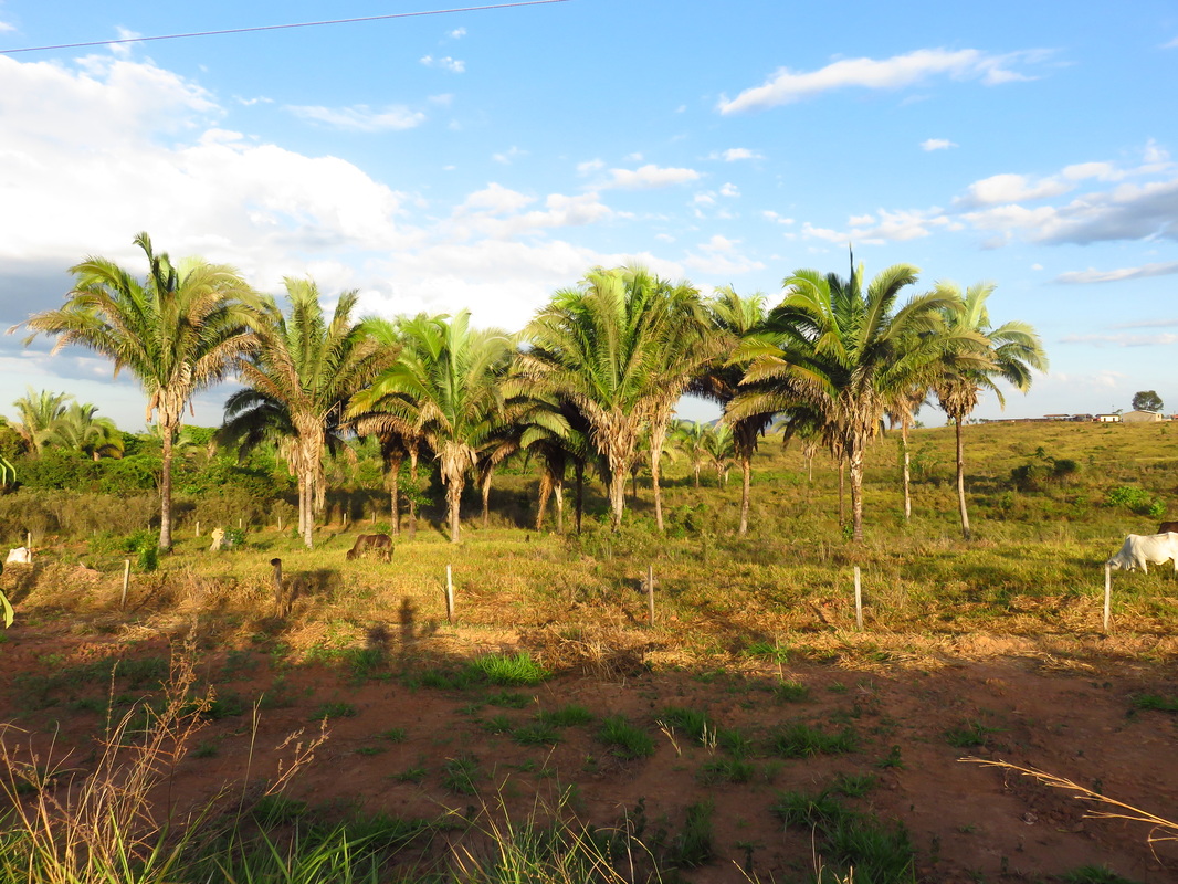
Babacu palms, parrots nest within the base of the fronds..
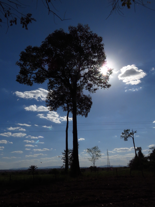
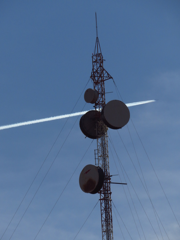
A remnant of what must have been................. The pylon in the background and others like it are the modern day giants of the landscape.
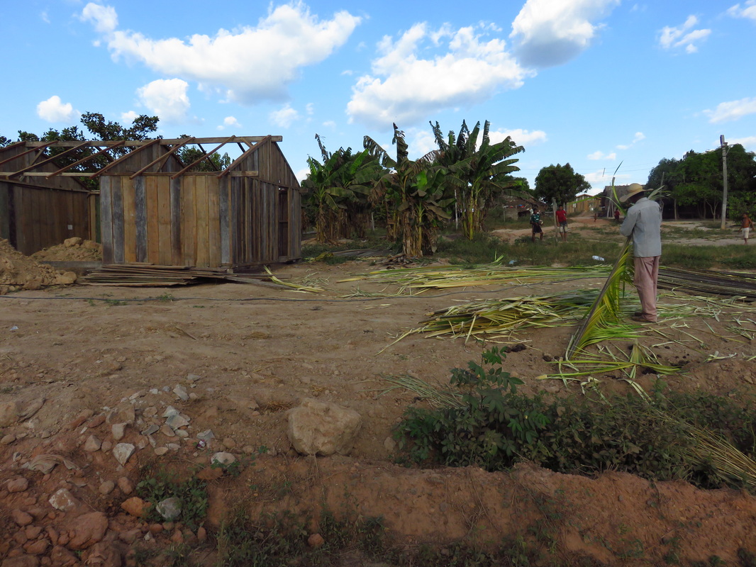
Preparing palm fronds for roofing
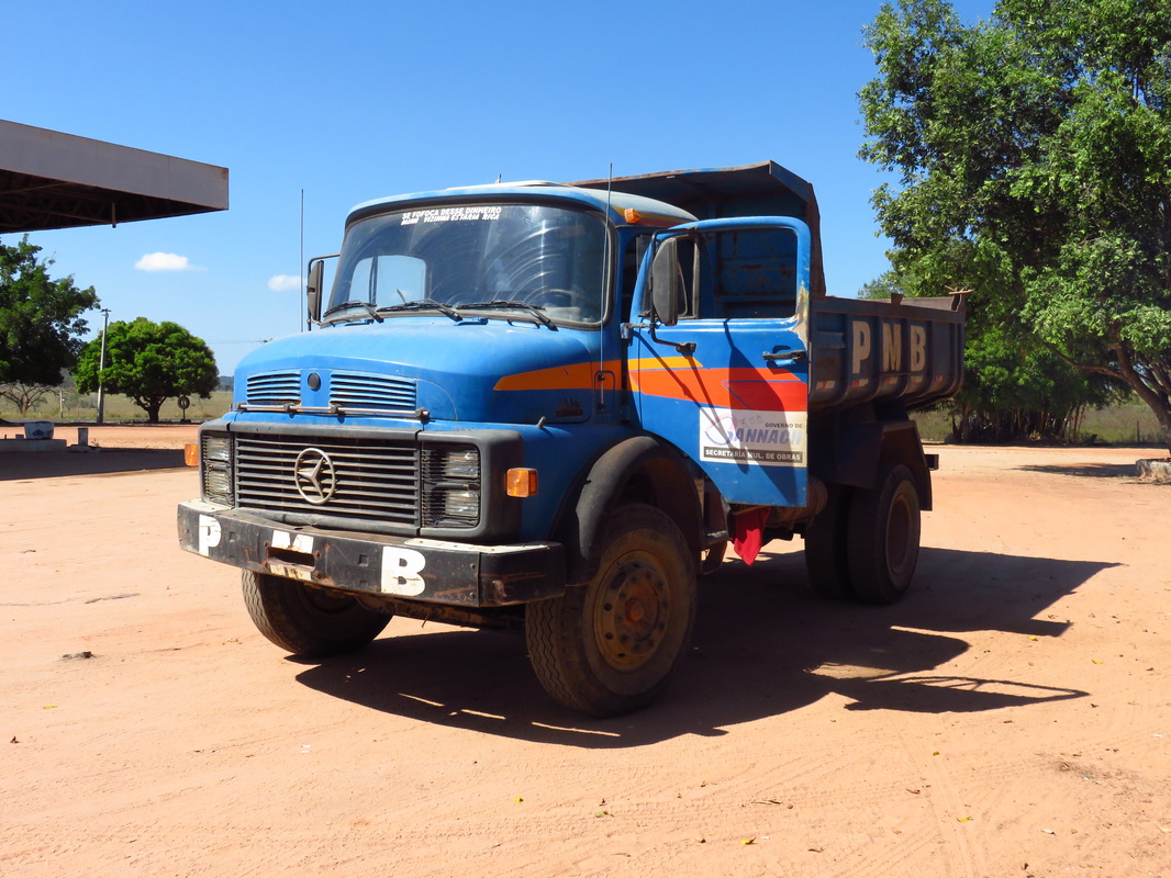
These old work horses are still hard at everywhere, especially fitted as cattle transport.
Sth of El Dorado, Jacaré habitat in background.
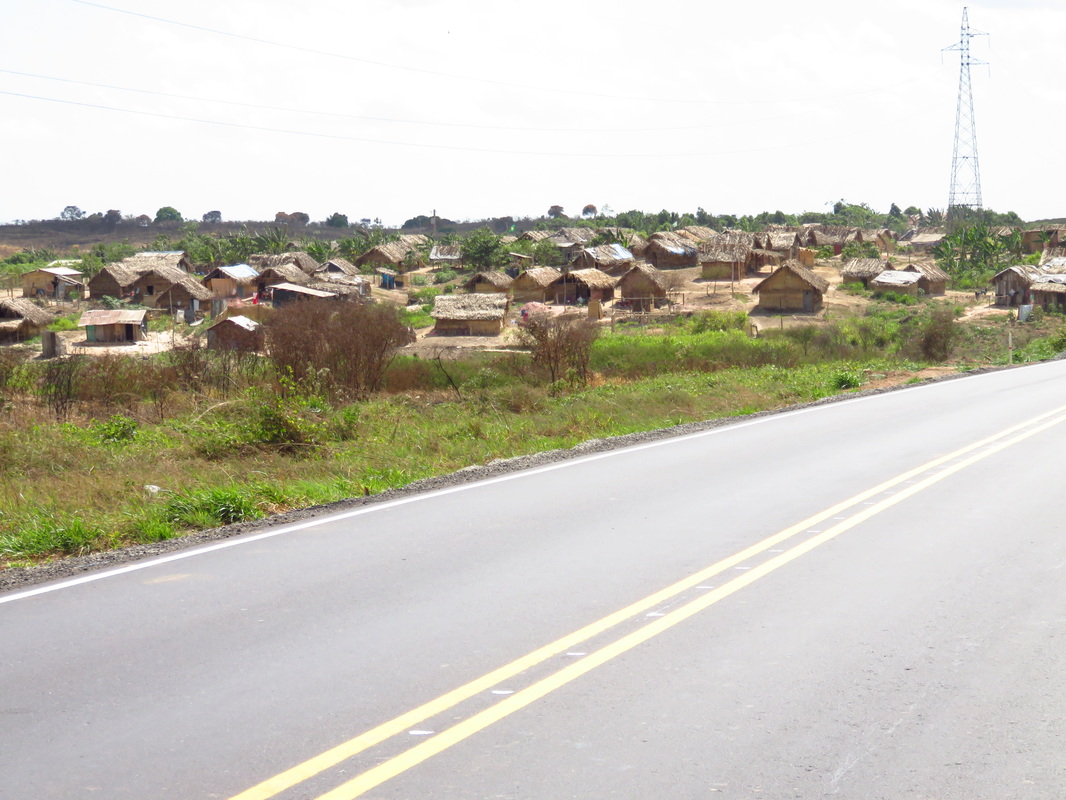
New settlements of largely thatched roofed adobe homes. South of Marabá.
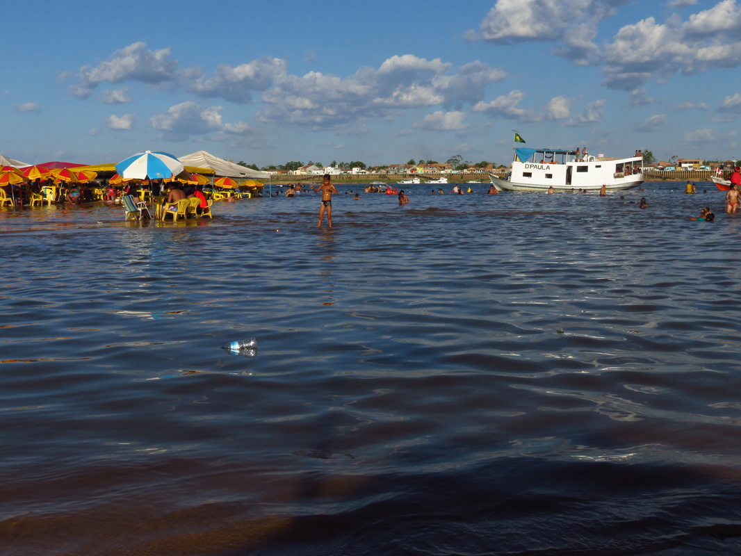
Bar tables were in knee deep tepid water, the river was remarkably clean.
There were thousands of people here.
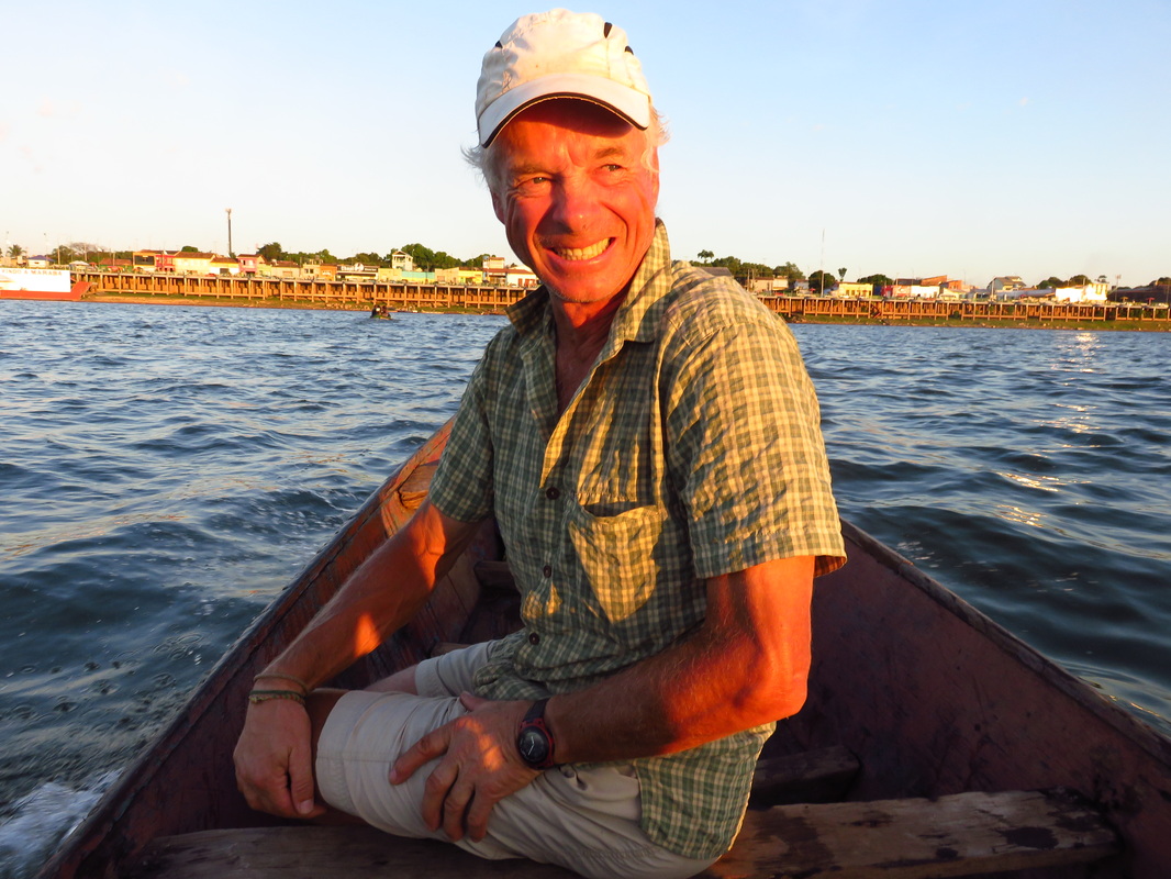
Heading back to town . The atmosphere on the island was so laid back, so Brazilian. The lifeguards told me drunks are a problem at the end of the day.
It was one place where company would have been so great.
The life guard tent.
|
I wonder what position the satellite dish comes on the list of necessities for survival?
Having said this, of shelter, water, food and fire, it is a "want" not a need.
Clever marketing creates the perceived need.
Loving the coco milk, a ride in boxer shorts for part of the day.
At $1 each they are superb value, even better when the young, soft flesh is consumed
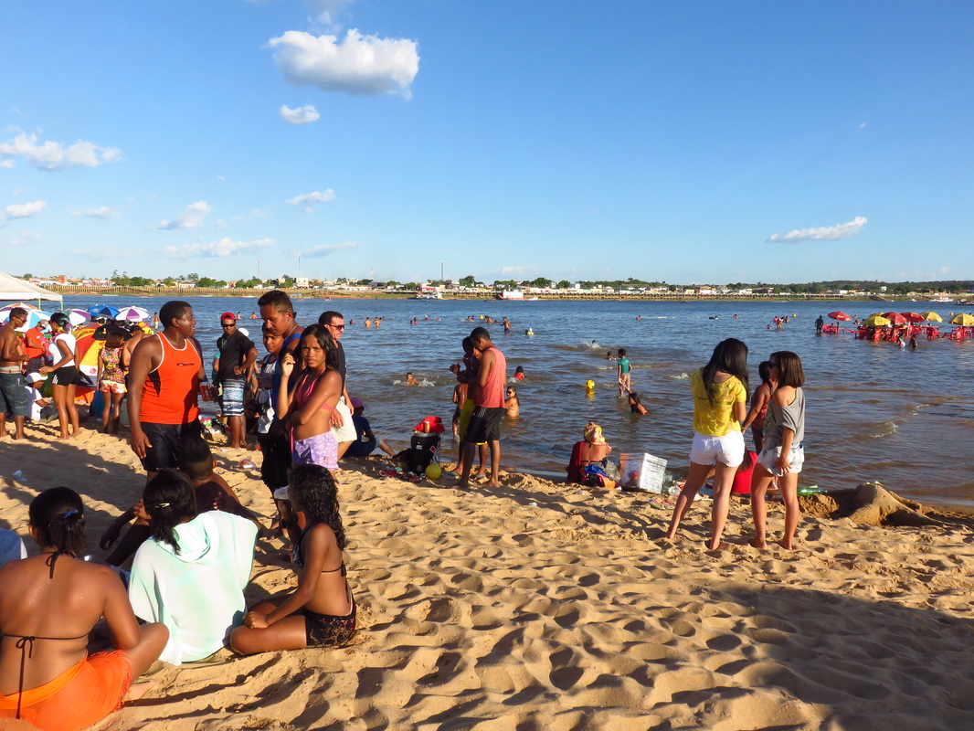
Praia do Tucanaré, Maraba.
Such a fantastic place to spend Sunday afternoon swimming, a few beers, listening to music and just enjoying the whole scene.
Marabá city back across the river Tocantins.
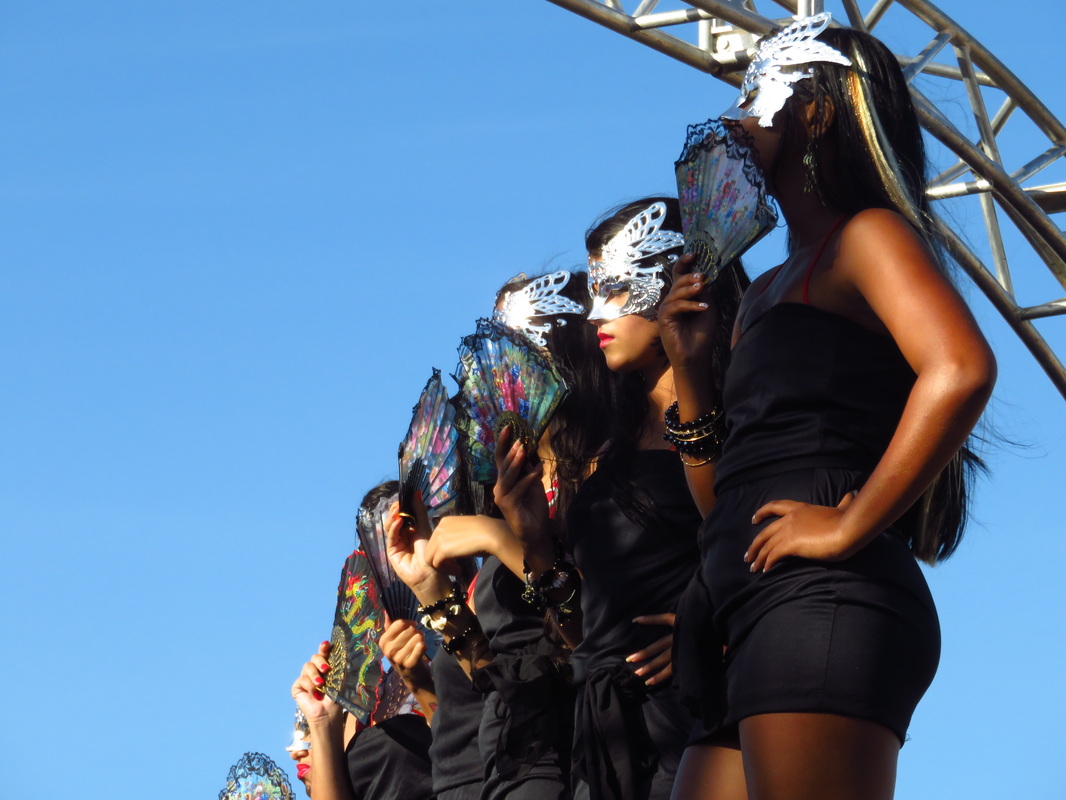
There was in addition to this, a bikini parade. Needless to say some time was spend in the large audience!
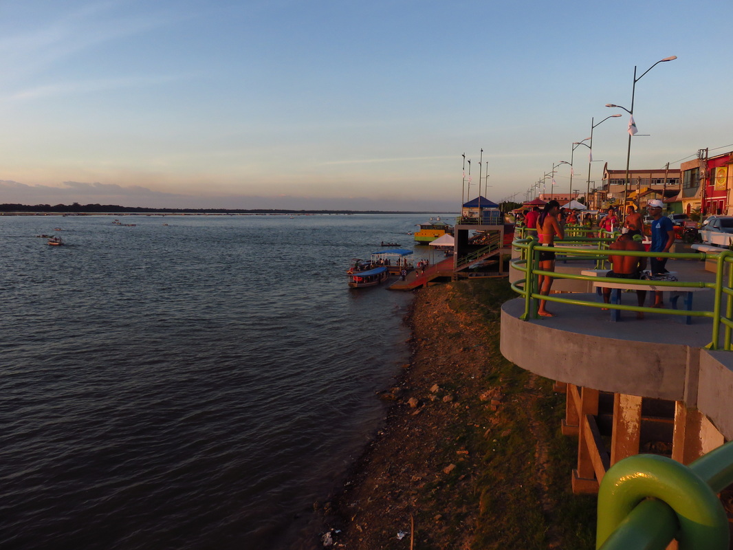
Marabá foreshores, Rio Tocantins. The island is dry for 6 mths a year. in the wet season the water is only a metre or so below these decks.
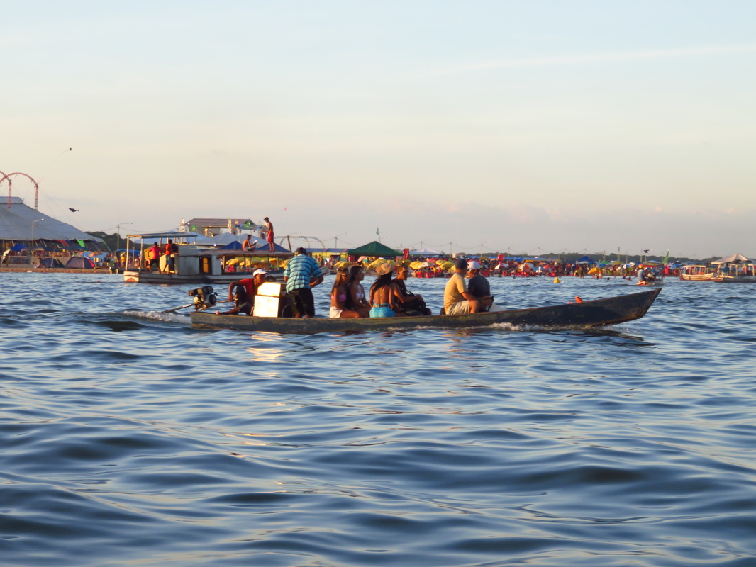
many were heading home near the end of the daylight.
|
Brazil and the South American countries are coming of age. This continent will be such an exciting place to be in the coming years.
